
You checked the forecast, plotted your course, and left on time. Then you arrived two hours late and nearly scraped a sandbar on the way in.
Sound familiar? Turns out the weather wasn't the culprit. Water movement was.
Most sailors don't think about sailing with currents and tides until something goes wrong. In this article, you'll learn what these forces actually do to your boat, which tools to use, and how to time your departure.
What’s The Difference Between Tides and Currents?
A lot of sailors think tides and currents are the same. They’re not.
Tides are the vertical rise and fall of the sea surface caused by the moon's and sun's gravitational pull. Currents are the horizontal flow of water that physically pushes your hull sideways or forward as you sail.
Both affect your boat, but in different ways.
Tides determine whether you have enough depth to enter a harbor. Tidal currents determine where your boat actually tracks on the water, versus where your compass says you're going.
Two numbers track this relationship:
Course over ground (COG) is the direction your boat actually travels across the sea floor.
Speed over ground (SOG) is how fast you're moving relative to the sea floor, not through the water.
When a tidal current cuts across your path, your COG drifts from your compass heading, even if everything looks fine from the helm. That gap is exactly what catches sailors off guard.
Why the Tide Clock and the Current Don't Always Agree
Tides and currents don't always move in sync. Current reversal in a channel often lags behind the tide height change by 30 to 90 minutes. High tide at your destination doesn't mean you have slack water to sail through.
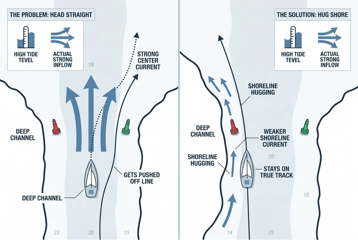
A few situations where this shows up most often. In narrow channels, current runs fastest at the center and weakest near the edges and inside bends.
At inlet entries, the right time to cross is driven by current direction. On shallow bars, tide height alone doesn't guarantee safe depth. Timing matters as much as the number itself.
Four Tools That Tell You What the Water Is Actually Doing
You can't feel a 1.5-knot cross-current until you're already off your line. These are the tools that warn you before that happens.
Nautical charts mark depth contours, channels, shoals, and hazard features so you know where current is likely to concentrate or shift.
Tide tables list predicted high and low water times and tidal range for your area.
Current charts show water flow speed and direction at specific times during the tidal cycle. These are separate from tide tables and just as important.
Marine GPS with current data overlays tidal predictions on your route and flags timing issues at each waypoint.
That said, no tool replaces watching the water. Floating debris, surface ripples, and eddy lines behind channel markers all show what the current is doing right now.
What Is the Rule of Twelfths and Why Does It Matter?
The rule of twelfths estimates how much of the tidal range returns each hour after low water. The tidal range doesn't rise in a straight line. It starts slow, accelerates through the middle hours, then slows again.
In a 12-foot tidal range, the first hour after low tide adds roughly 1 foot. The second hour adds about 2 feet. Hours three and four add about 3 feet each. That's where most of the depth returns.
So if someone tells you to leave two hours after low tide, you're still only working within 3 feet of a 12-foot range. That's a lot shallower than most people expect.
Here’s an example: Say the tidal range at your inlet is 12 feet, and you need 4 extra feet of depth to clear the bar. Two hours after low tide, you only have 3 feet back. You're still a foot short.
Wait for three hours, and you've got another 3 feet. Now you're comfortably in the clear. Leaving at two hours looks fine on paper, but the calculation says wait.
How to Factor Tides and Currents Into Your Route Plan
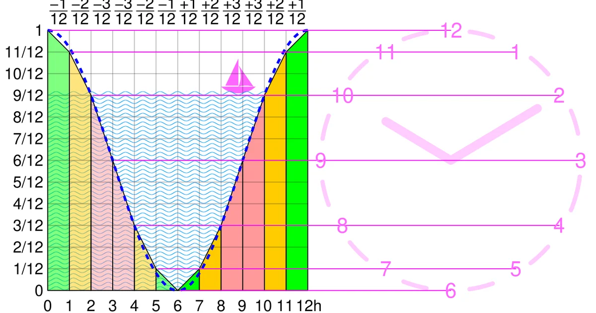
The rule of twelfths: how the tide rises and falls across the six hours between low and high water, in twelfths of the total range. Image: Cmglee, via Wikimedia Commons (CC BY-SA 4.0).
Most sailors check the weather before a passage. Fewer check the current data along the full route. That's where plans fall apart.
Here's how to do it properly:
Check the tidal cycle for every point along your route. Conditions can differ significantly at multiple spots on the same passage.
Find where depth matters most, such as shallow bars, inlet entries, and bridge clearances. Apply the Rule of Twelfths to work out your safest crossing window at each one.
Pull current predictions for each waypoint. Check the set and drift at the time you'll actually be there.
Pick a departure time that catches favorable current through the hardest sections, or at least avoids peak opposing flow.
Why Isn't Your Compass Heading the Same as Your Actual Track?
The current pushes your boat sideways, whether you notice it or not. Your actual path over the sea floor combines your speed through the water with wherever the current is sending you.
Here's the math in plain terms. A 6-knot boat with a 2-knot current behind it makes about 8 knots SOG.
That same boat in a 2-knot opposing current drops to 4 knots SOG. That's the same 24-mile passage taking 3 hours with the current or 6 hours fighting it.
Here are two example scenarios to make that explanation clearer.
Scenario 1: Harbor Crossing at Flood Tide
Picture this: you're crossing a harbor at flood tide. Your sailboat makes 5 knots through the water, a 2-knot tidal current pushes east across the channel, and your destination sits due north.
If you just point north and sail, that eastward push quietly moves you off your intended track. After one hour, you're about 2 nautical miles east of where you meant to be, even though your compass heading looked right the whole time.
The solution is to aim slightly west of north so the eastward set cancels out and your actual track stays true. That adjusted heading is what navigators call the course to steer.
Scenario 2: Channel Entry With Misaligned Tide and Current
Here’s another scenario. You're timing a channel entry and assume you've got slack water because the tide is near its high. But the current reversal didn't line up with the tide height change.
If you head straight down the center of the channel, you'll hit stronger flow than expected. It's not what the tide table suggested, and it'll push you off your line before you realize what's happening.
If you hug the shoreline instead, where the current runs weaker regardless of tide stage, you make cleaner and safer progress.
Navigation Habits That Prevent Groundings and Missed Arrivals
Most grounding incidents don't come from bad weather. They come from assumptions that weren't checked against real conditions. A few specific habits close that gap.
Always treat current reversal and tide height change as separate events. They're connected but offset. Checking one without the other gives you half the picture.
Watch the water, not just the screen. GPS shows you predicted conditions. Floating debris, ripple patterns, and eddy lines behind markers show you what's happening in the water.
Account for weather effects on the tidal cycle. Wind against an ebbing tide creates steep, short seas. Storm surges push water levels higher than the tide table predicts, which means bar depths can shift without warning.
Cross-reference current charts, tide tables, and what you see on the water together. No single source gives you the full picture.
Put Tidal Navigation Into Practice With ASA 104 at Sailing Virgins
The ASA 104 Bareboat Cruising course at Sailing Virgins is where these skills get tested in some of the world's best sailing destinations.
The curriculum covers everything this article walks through and more:
Route selection and weather window timing
GPS and chartplotter operation, including backup strategies
Passage planning from departure to anchorage
Real-time decision-making when conditions shift mid-passage
By the end of seven days, you'll hold an ASA 104 certification that qualifies you to bareboat charter yachts up to 45 feet at most charter companies worldwide.
If you've got ASA 101 and ASA 103 under your belt, or equivalent coastal sailing experience, you're ready to step up.
Find your course at Sailing Virgins and choose your destination!